EDWARDS AQUIFER SYSTEM OF CENTRAL TEXAS
HYDROLOGIC GEOLOGY OF THE BALCONES FAULT ZONE
The Edwards Aquifer is composed of Cretaceous-age limestone formations of the Edwards Group. Three major aquifers in Texas are formed from some or all of the Edwards Group – the Edwards Balcones Fault Zone (BFZ), the Edwards-Trinity (Plateau), and the Edwards-Trinity (High Plains) aquifers. The Edwards BFZ Aquifer in the Hill Country region near San Antonio is the focus of this webpage.
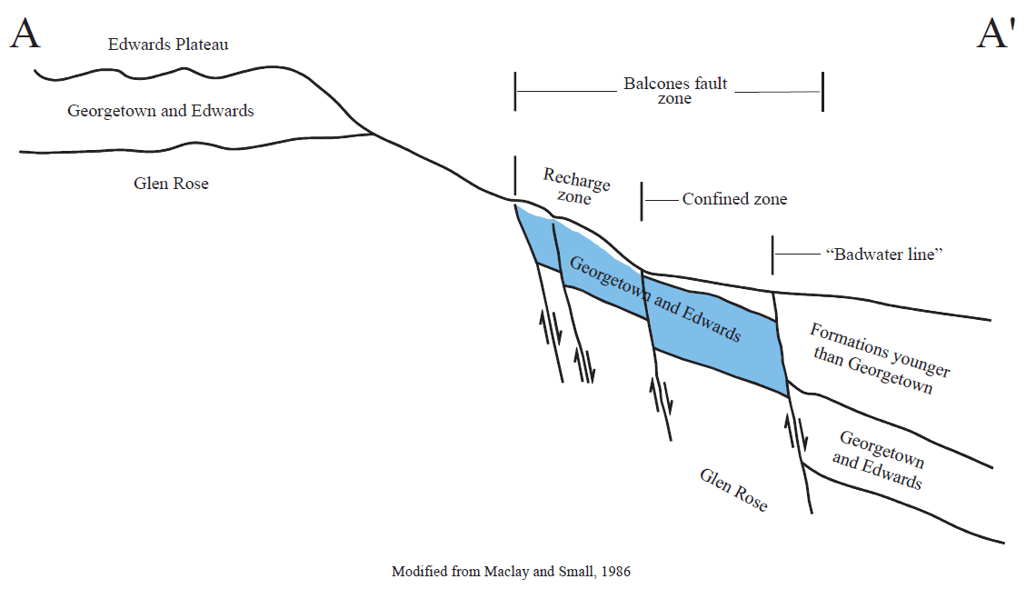
The rock layers are found at the surface or subsurface in the Central Texas region and comprise distinct zones of the Edwards Aquifer. Considered to be capped by the Del Rio Clay, the Georgetown Limestone, strata of the Edwards Group, and the Comanche Peak Limestone overlies the Glen Rose rock layers of the Trinity System except where faulted blocks raised the older rocks above the younger Edwards strata. Thickness of the Edwards BFZ is estimated between 200 and 600 feet. The faults, trending northeast to southwest, are known as the Balcones Escarpment which can be seen along the I-35 corridor. The land surface of the escarpment separates the Hill Country to the west from the rolling prairies to the east.
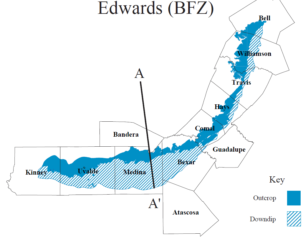 Source: TWDB Rpt 345, Edwards (BFZ)
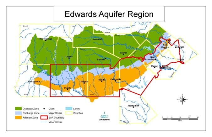
Map from Texas Water Development Board (TWDB) Report 345 – summaries of major and minor aquifers in Texas.
Understanding an aquifer typically begins with the rock layers, or strata. Many field and lab studies have helped develop the scientific and geologic knowledge of the Edwards Aquifer, not only in its different layers but also different regional basins. From a US Geological Survey report published by TWDB (Maclay and Small, 1986), a comparison of the Edwards strata in three basins demonstrates how the deposition of the layers varied in time and location:
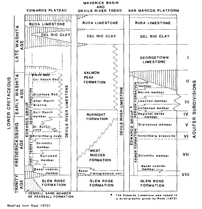 Source: TWDB Rpt 296
A simplified version of the stratigraphic column of the Edwards Aquifer and associated rock strata in the San Antonio region:
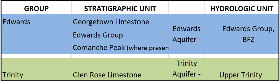 Source: TWDB Rpt 345
 Source: TWDB Rpt 345, Edwards (BFZ)
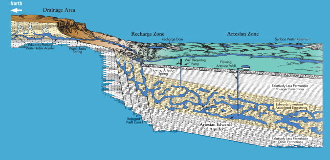
The cross section shows 3 primary zones of the Edwards that are important to understanding water movement from the surface through the aquifer. The upland area of the Edwards Plateau is known as the “drainage zone”. This area of Edwards Group rock outcrops allows rainfall and surface runoff to infiltrate into the subsurface. Where uplifted Glen Rose rocks are present at the land surface, water moves into the Trinity system. The “recharge zone” occurs where the Edwards strata are exposed in the lower reaches of the Hill Country. As shown in the cross section, this area is highly faulted, further supporting rapid flows of water into the aquifer. The “confined zone” is the region of the Edwards Aquifer under pressure with artesian springs and wells. Once the Edwards strata are downdropped east of the “bad water line,” the groundwater is more saline than fresh.
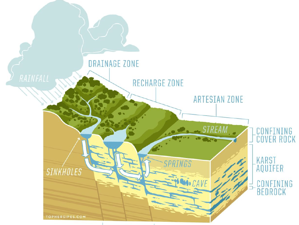
A diagrammatic view of the flow of water through the karstic aquifer:
 Source: The Meadows Center
The US Geological Survey has conducted many studies of this critical aquifer system over the years. From USGS Water Resources Investigation Report 94-4093, here is a large scale map and cross section of the system:
Detailed studies of the Edwards Aquifer by TWDB, US Geological Survey, and researchers at academic institutions have helped to build a thorough understanding of the complex water flow through the layered, faulted, and honeycombed strata. Some features of the Edwards include:
- At least 8 hydrostratigraphic or water-bearing zones have been defined in the Edwards, some more permeable than others.
- The rock strata have been leached and re-crystallized, resulting in increased pore spaces and high interconnectability in some, but not all, of the rock layers. Thus, groundwater movement and flow rates are highly varied.
- Hydraulic conductivity measured in wells range from 2 to 31 ft/d. Transitiveness range from “negligible” to 2 million ft2/d (TWDB Rpt 296). The storage coefficient ranges from 10-4 to 10-5. According to TWDB Report 345 concerning the Edwards BFZ, well yields are considered moderate to large, up to 24,000 gallons per minute in a 30-inch diameter well drilled in Bexar County.
- The freshwater zone to the west of the escarpment requires very little to no treatment for drinking water purposes, while groundwater to the east in the “bad water line” contains higher concentrations of dissolved solids. These trace minerals are due to the presence of pyrite and gypsum in the rocks.
ADDITIONAL RESOURCES:
Detailed information about the Edwards hydrogeology can be found at:
Edwards Aquifer Authority – Hydrogeology and “Visit the Aquifer”
The Edwards Aquifer Website, Gregg Eckhardt
Barton Springs/Edwards Aquifer Conservation District’s Aquifer Science
USGS Edwards Aquifer and Barton Springs online resources
USGS Geologic Map of the Edwards Aquifer Recharge Zone, 2006