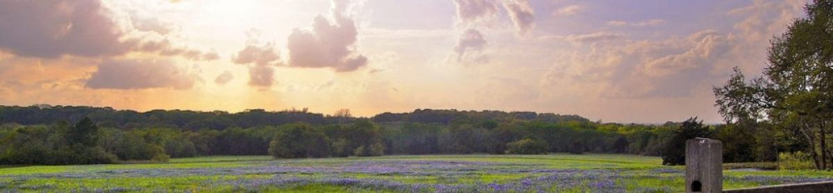
CENTRAL TEXAS SPRINGS
Springs in Texas have always been a part of the landscape. They provided water to native tribes over the centuries as documented in research at Aquarena Springs, and were part of the stops along the cattle drive trails in the 1800’s. They are found in diverse regions across the state including the Hill Country Regions of Central Texas.
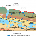
Springs are found in many settings and their waters may flow from shallow or deep levels in the underlying aquifer. Springs are formed in hard, fractured rock systems such as the Trinity or Edwards aquifers through slow dissolution of porous, fractured layers of the systems. It can take many thousands of years for a spring system to be created.
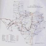
Historically, springs were critical to survival in some areas of Texas. The map to below has locations of the old trails and routes. Small Springs can be found on many ranches and rural areas throughout the Hill Country. Small springs can be found on many ranches and rural areas throughout the Hill Country.
Just as importantly, springs are linked to unique features in urban areas. Gunnar Brune began mapping these springs and collecting data on their flows and site characteristics in the 1960’s. He completed volume 1 of his “Springs of Texas” in 1975. In that volume, he recorded over 281 springs, not including saline springs. Using historical archives compared to field data in the 1970’s, he documented the loss of springs from around 1500 to 1973 in the map to left. The red symbols are for large springs and the blue symbols for springs of historical significance.
Of importance to the Hill Country: this 1975 report documented that of the 281 recorded springs, 139 have their sources in the Edwards and Edwards-Plateau aquifers.
JACOB’S WELL
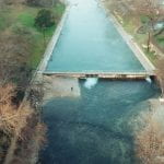
Jacob’s Well is one of the natural treasures of the Hill Country. Located near Wimberley in Hays County, the spring typically flows around 3.5 cubic feet per second from the Trinity Aquifer, supporting downstream flows in Cypress Creek.
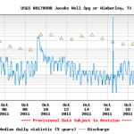
Due to lowered aquifer levels in the Cow Creek Formation, the hydrostratigraphic zone for artesian flows to Jacob’s Well, the spring discharges are currently far below the median flows for the month of October over the last 5 years.
COMAL SPRINGS
Located in Landa Park, New Braunfels, the Comal Springs system is the largest in Texas. Sourced in the Edwards Aquifer, flows have been tied to the index well J-17 in Bexar County; when the water levels in J-17 drop below 620 feet, the flows are Comal Springs are also decreased. The springs ceased flowing in 1950’s drought of record. Should the current drought continue, there are concerns that the spring system could stop flowing.
Current flows can be found on the USGS Real-time Data Series for the USGS gauge 08169000 “Comal Rv at New Braunfels, TX”. As of November 8, 2011, the Comal gauge shows flows well under the daily median of 290-300 cfs. Flows in the previous 10 days are under 200 cfs.
For more information about the spring system, its history and uses, spring flows, and a photo gallery that includes historical postcards, see: The Edwards Aquifer website by Gregg Eckhardt.


BARTON SPRINGS
Although a relatively minor spring in the Edwards Aquifer, Barton Springs is an intregal part of Austin culture. The swimming hole is an important recreational asset to the city. It has been closed on numerous occasions due to contamination of various pollutants – a result of the waterbody’s proximity to dense urbanization.
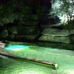
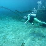
Also known as Aquarena Springs, this spring system is the 2nd largest in the Hill Country. Archaeological surveys and cores from below the bottom of Aquarena Springs indicate humans lived around the springs at least 11,500 years ago. More than 200 spring outlets have been identified in the system. Normal flows are around 152 cfs; low flow during 1950’s drought was 46 cfs. The springs are critical habitat for 5 species (Fountain Darter, Texas Blind Salamander, San Marcos Salamander, San Marcos gambusia, Texas Wild Rice).
Today the area is undergoing restoration activities that have been more than 10 years in planning between Texas State University-San Marcos, The Meadows Center for Water and the Environment, the City of San Marcos, U.S. Fish and Wildlife, and the U.S. Army Corps of Engineers. The Habitat Restoration Project will remove buildings that are in the 100-year flood plain such as the old restaurant, but leave the historic hotel, now housing The Meadows Center and Texas Parks and Wildlife Department staff. A new Visitor’s Center is currently being built and the glass bottom boat tours will continue.
Extensive and detailed descriptions of the archaeology, hydrogeology and history of the San Marcos Springs system can be found on the following web sites:
- The Edwards Aquifer/San Marcos Springs, website by Gregg Eckhardt
- Edwards Aquifer Authority – widget for aquifer conditions in Bexar (J-17 well), Uvalde (J-27 well), Comal Springs, and San Marcos Springs
ADDITIONAL RESOURCES:
Many Texas ranches and rural lands have had springs and seeps. Unfortunately, with the current drought conditions, some of these have decreased flows or have dried.
There are many excellent guides to springs, their native species, and conservation projects. This webpage relies on the following resources for in-depth information about springs in general as well as specific springs:
- USGS online information about the water cycle
- Texas Water Development Board Report 189, Gunnar Brune, “Major and Historical Springs of Texas” (1975)
- Texas WaterMatters, “Spring Owner’s Guide“
- Edwards Aquifer Authority
If you have a story about a spring or seep, we’d love to hear from you! Just contact rivers@txstate.edu.